Newark, New Jersey's infrastructural landscape
Uday Schultz
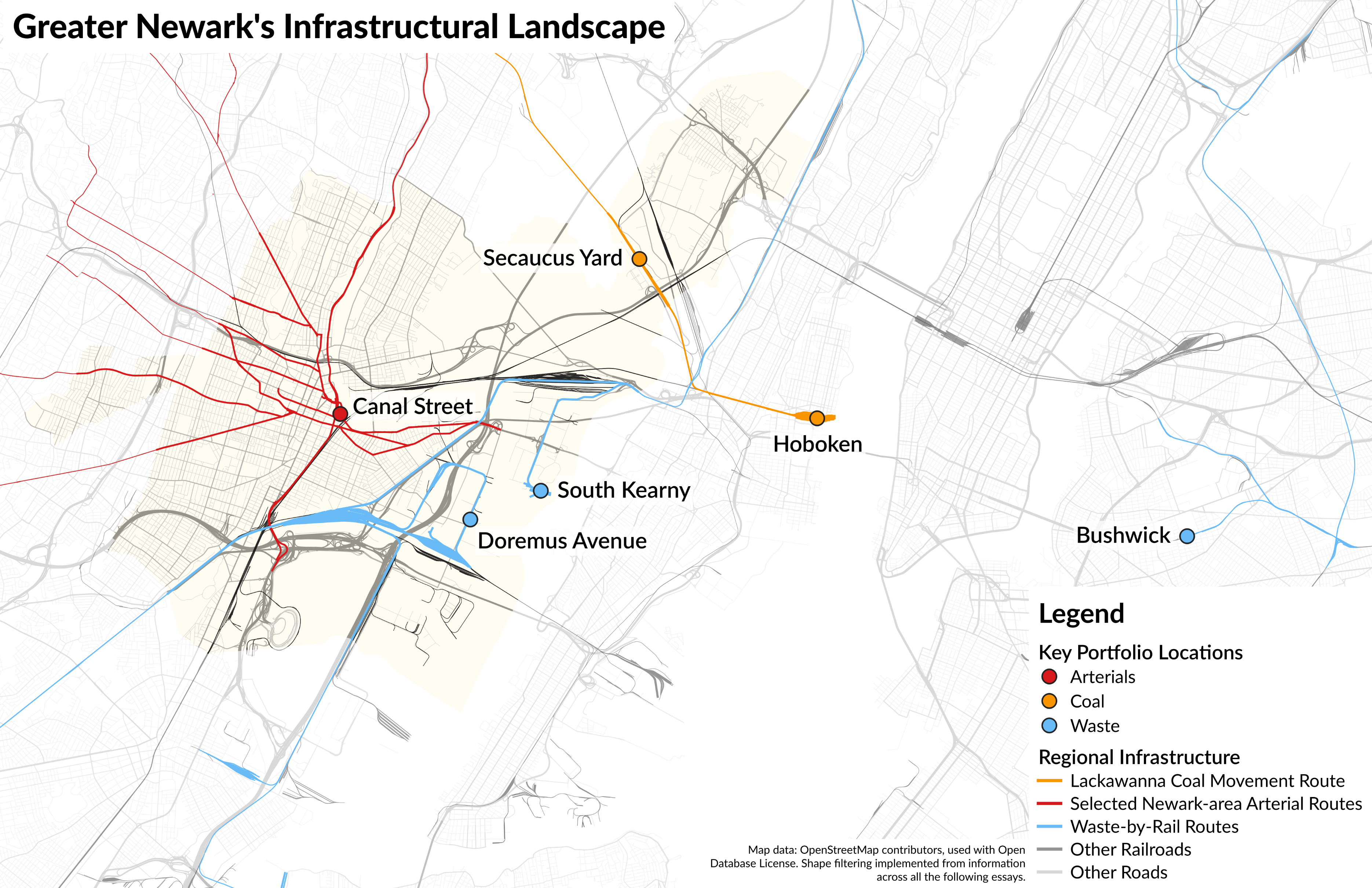
Introduction and Regional Map
 About two months before COVID swept across the United States, I found myself in a muddy field on a clear, January day. The weather was cold enough to freeze the pooled water on the ground, but not the mud beneath it; my feet cracked and slid as I made my way over the landscape. Across a driveway from me was a pile of shipping containers. Bathed in the low winter light, they rose fifty feet into the air, visibly leaning this way or that as they rested on the cold ground below them. In the distance, trucks braked, and trains sounded their horns; the mud on which I stood lay at the heart of Newark, New Jersey's infrastructural landscape.
The stories of material infrastructure are often related in histories and narratives whose primary projects lie outside the networks they trace. We read about highways, but usually only in their impacts on a particular place; we hear about railroads, but only in their relation to industrialism's life in a mine or factory. These narratives that draw infrastructure into place-based conversations with social, environmental, legal, labor, and economic history are immensely valuable, and have produced groundbreaking historical works. Yet in bounding the histories of systems in single locations, they often miss the indelibly systemic quality of infrastructure. In the age of climate change, in which transport itself makes up an increasing share of national and global emissions, and in which the reconstruction of the built environment to facilitate greener living stands as a central challenge of our time, that gap in analysis shines even brighter with every passing day. What would happen if we let infrastructure lead us in telling its stories?1
Tracing networks across history often brings us back to bounded places. No human system is symmetric; our built environment embodies and enables the concentration of power and capital in particular urban and industrial spaces. One such node is Newark. Lying at the western edge of New Jersey's famous (or, perhaps, infamous) Hackensack Meadowlands and ten miles from Midtown Manhattan, the city is a famous New York satellite. But it is also a gateway, and a hub, a place whose landscape is riven with highways, bus routes, railroad lines, ports, airports, warehouses, and muddy container storage lots. Though the stories told in this portfolio might concentrate on a small corner of continent-spanning systems, they aim to do so with one eye always pointing outwards, seeking to synthesize the social, environmental, and political ramifications of Newark's infrastructural entanglements with the contingent history of the city itself.
This portfolio spans four essays, each of which sheds light on different aspects of Newark's life as a node. In the first of these, I discuss the movement of coal on the railroads of Northern New Jersey, highlighting the interplay between coal's materiality, markets, and reliance on the freight yards of the Meadowlands as animating nodes in the distribution network. The second turns to the streets of Newark itself, discussing the ideologies of planning that created the dangerous, auto-oriented arterial roads linking Newark to its suburbs, and reflecting on the ways infrastructure can express social values and hopes. In a narrative that bridges the Hudson River, the third essay returns to freight movement, detailing the intersection of environmental activism, transport networks, and deindustrialization in shaping the modern waste disposal system around New York City into a call for geographically expansive, and systems-inflected activism. The final essay is an op-ed; it concludes the portfolio by considering Newark's transport landscape as not just a crucible of geographically disparate forces, and of infrastructure, but also as a roadmap for the expansive industrial policy we desperately need to address our current climate crisis.
Individually, each of these considers the layering of environmental, social, economic and political contingency across and along routes of transport. Collectively, in their dedication to understanding Newark as a city at the heart of multiple material and economic systems, they demonstrate one way of holding the specificities of individual places alongside the reality of immense and intimate trans-local interconnection.
Coal to Water
Coal has never been a homogenous mineral. Historically sold in varieties such as "pea," "lump," and "dust," its entry into furnaces has not been one stratified just along the familiar lines of rank, but also on those of size, level of impurity, and ash content. Actualizing this diversity required a transportation and distribution system capable of allocating these plural coals to tens of thousands of heterogeneous end users. That project of distribution was complex, essential to the transformation of coal from a rock to a commodity, and central to the history of American infrastructure.
Few places bear more scars of coal's complexity than Northern New Jersey. In the swamps and tidal lands between the Passaic and Hudson Rivers, and along the banks of the Arthur Kill to those swamps' south, railroads constructed a network of yards, docks, main lines, and terminals to animate the movement of goods across the Hudson River and into New York. These termini helped transform Greater Newark into an infrastructural node: the city's freight yards were neither origins nor destinations for the traffic they served, but their spread across the Meadows transfigured that landscape into one deeply tied to industrialism. Some of those terminals were multipurpose, carrying food, fabric, merchandise, and metals into Gotham. But with sixty percent of rail tonnage into the New York region consisting of coal in 1914, the challenges of coal distribution lay at the heart of railroading's life in Newark's landscape.2

The problems presented by coal's materiality were twofold. Firstly, mining regions generally did not specialize in the production of specific types or sizes of coal. To fill barges with coal of only a single type, switching crews in North Jersey's railroad yards had to break down trains from northeastern Pennsylvania's coalfields and re-sort their cars with those of other trains to make solid 'blocks' carrying the same type of coal. These could then be dumped into barges for transport to New York.3 Secondly, the final sale and allocation of coal took place not at the mine, but at the waterfront coal terminal. Anthracite sales were rarely direct: as of the early 1920s, about 73 percent of anthracite was sold to consumers and retailers through wholesalers, rather than from the mine itself.4 Because retailers and many industrial consumers purchased anthracite on the spot market—which is to say, as their immediate needs dictated—and because railroad transit times from mine to metropolis tended to be both long and unreliable, the thousands of cars of wholesaler-owned coal rolling into the Meadowlands rarely had a known destination. Rather, the wholesalers who billed them would send them to portside yards, where they would wait as the owner of their contents sought buyers and higher prices.5 Given the number of different anthracite sizes, the disparate consumption patterns between each of those markets, and the wide swings in price that typified anthracite coal dealing, loaded cars might sit in yards for weeks or months before sale.6 Railroad infrastructure thus became central not just to the movement and organization of this heterogeneous landscape of coal use, but also to the animation of market relations in the coal industry itself. Railroad yards (and coal storage piles) made possible the abstract vacillations of commodities markets. They were sites where freight transport was asked to serve not just as a means of connection, but as a means of regulation, keeping production and consumption profitably decoupled.
These multiple demands shaped the geography of the region's railroad infrastructure, and the political battles surrounding them. Most New Jersey railroads segmented their operations. Each would have a large inland classification yard, where freight destined for points in the region would be sorted, and a waterfront yard, where switching crews would place traffic alongside warehouses, on coal trestles, or onto barges for movement across the harbor. Though this divided system defined the movement of all cargoes, coal's sheer volume made its problems preeminent. Take the Delaware, Lackawanna & Western's yard complexes at Secaucus and Hoboken as they existed around the turn of the twentieth century. The DL&W was a coal railroad par excellence: in 1901, more than 60 percent of its revenue was derived from coal movement, much of which was mined by the company itself.7 Like most Northern New Jersey railroads, its facilities were constrained by topography and urbanization. The carrier's waterfront yard and pier complex in Hoboken suffered this problem acutely, hemmed in by the river to the east, the fast-growing cities of Hoboken and Jersey City to the north and south, and other railroads and the escarpment of Bergen Hill to the west. Yet Hoboken's piers had to move immense and increasing quantities of freight from trains to barges. Lest its tracks be clogged with unsorted cars, it needed an antechamber that could prepare rail traffic for its entry into the frenetic and cramped space of the waterfront yard. That space was its Secaucus yard, where the railroad grouped coal cars into no fewer than 32 different size classes, and further subdivided shipments by their wholesaler.8

As crews moved cars around the railroad's yard, the Lackawanna's clerical workforce toiled to manage the flows of information created by these cars' travel. Around the turn of the twentieth century, the Lackawanna invested heavily in a company telephone network to speed the flow of information over its lines and reduce pressure on telegraphers. Though the Lackawanna's initial use of telephones evolved out of the large volume of information travelling within the compact area of Northern New Jersey, the network grew rapidly, and by 1903, facilities across the entire system had been linked with telephones. The primary users of these lines were the Lackawanna's traffic department, responsible for tracking and communicating the flow of freight across the network, and its mining department, whose employees were charged with ensuring that the railroad's coals sated fast-changing demand—and that its cars, in turn, met mines' transport needs. So, as the parade of loaded coal trains trundled into Secaucus, not only would a conductor pick up a switch-throw lever, but so too would a clerk pick up a phone, letting the shipper or mine traffic department know that their car had arrived. All that was left to do, then, was to wait—for the right price, for the shipper's call, for the clear signal, and for a passage onto the open waters of New York Harbor.9 Secaucus's role was to be that space of suspended animation, holding its congestion away from the constant movement of Hoboken's yards and piers.10

This infrastructure of movement and storage changed continuously, in part because of the structure of anthracite mining itself. Much anthracite coal—75 percent as late as the 1920s—was mined by companies affiliated with railroads.12 Though railroads' adaptations to the coal market (their construction of large storage yards, their gradation sorting, and so on) were most directly the product of their interactions and transport contracts with wholesalers, who owned the coal leaving Pennsylvania's mines, they had a broader vested interest in higher mine-mouth anthracite prices. Those ties meant that railroads were extremely willing to invest in enlarging coal storage capacity. Because anthracite was a common home heating fuel, its use varied by season. Raw coal production varied less, however, creating a disjunct. So as to not sell coal to wholesalers at low rates, railroads and their affiliated coal companies spent the last decades of the nineteenth century building out storage facilities where they could hold coal through the summer.13 These yards and piles became common sites along anthracite railroads, strengthening the social and environmental bonds between Northeastern railroad towns and the anthracite trade.

This project of storage as a means of enabling profit had its limits; much as these sites were central to the animation of coal markets, they were central, too, to those markets' social challenges. During winters, when anthracite demand was strong, even slight perturbations in weather and transport could lead to 'coal famines.' These periods of scarcity were immensely aggravated by the anthracite market's structure: when prices rose dramatically, wholesalers had every incentive to withhold their coal in anticipation of further increases, which of course then caused those increases to happen. This upwards spiral was both an abstract strategy to profit from the swings of commodity markets, and also a physical phenomenon, in which thousands of loaded coal cars would accumulate in railroad yards near famine-stricken areas. As winter's frost settled upon the homes of New Yorkers, that dissonance—between plentiful rail-bound fuel and high retail prices—would, at times, breed acts of resistance. One news article on a New York area coal famine in 1903 told of "a large number of boys" tearing down railyard fences and taking "a considerable quantity" of coal before railroad-employed guards scared them away with threats of violence.15 What these frozen young men recognized was that the railyards were deeply political. With every expansion and every operational refinement that gave them more capacity to hold coal, railroads, coal dealers, and mine owners gained further market power: it was through these fenced acres of halted motion that anthracite capitalists could maximally realize their profits.
Today, little anthracite flows through Northern New Jersey. Yet many of the railroads, factories, and structures of capital that the mineral built persevere, their geographies and constraints animating and undermining New York's infrastructural life. They are living testaments to railroads' capacity to give material life to market relations.
The Roads Out of Town
American automobility is hegemonic. In much of the country, it is not only easiest to get around in a car, but actively dangerous or simply impossible to do otherwise. Our streets are designed with the vehicular citizen in mind, making cycling or walking into an exercise in bravery; our buses and train systems are underfunded and atrophied, putting mass mobility out of reach of many; our homes and businesses, surrounded in parking and set away from roads, are spaces by and for drivers. It is Hughes's "technological momentum" come to life—throughout the 20th century, many Americans voted, participated, and spent in such a way that elevated automotive lifestyles, ensconcing the dominance of its technological logic to such a degree that today, the car is something chosen by our landscape for us.16
Over the past decade, scholars and the press alike have increasingly interested themselves in the acts which generated American motordom. Those which have come to the front of minds have unsurprisingly been the most dramatic: the highways brutally cut through American urban cores, decimating dozens of disproportionately Black communities.17 Yet to focus solely on those great urban gashes is to view only part of the story. Supporting the project of massive highway construction was the creation of urban arterial road networks, one in which thousands of little cut-throughs, smoothings, and widenings incrementally altered urbanism's individual threads to befit the age of the car. With widely spaced crosswalks, fast-moving traffic, and concentrated commercial activity often lining their edges, this network of multilane roads is where the density of urban life comes in closest contact with the problematic assumption of automotive citizenship. In 2021, over 70 percent of urban pedestrian deaths occurred at this interface, with a disproportionate share of that impact afflicting nonwhite pedestrians walking in lower-income neighborhoods.18 By making the daily actions of urban life dangerously difficult to perform without a car, arterials complemented highways' severance of links between communities by fraying the fabric of urban life within them. Their danger and corrosive power begs the question: why did we create them?

This brings us to our map. Visually, it is hardly the most striking image of American motordom or urban planning, yet it encapsulates the incremental and historically contingent dynamics of arterial road creation. Drafted in 1922, the diagram lays out a series of street alterations along Newark, New Jersey's Passaic River waterfront. The purpose of these alterations was to expand streets. Canal Street was to grow to eighty-eight or one hundred feet; Ward Street would be cut through to the river; River Street and the plaza in front of the train station would each be widened. None of these modifications were individually major undertakings, and indeed, in many cases these street system edits would only appear incrementally as wider streets on city code maps translated into new structures set further back from roads. Nevertheless, these small changes transformed Newark's once walkable and transit-oriented core into an automotive landscape. In the wake of planners' ink, buildings, sidewalks, and safer streets gave way to automotive arteries.
The unavoidable question that arises from this map's dedication to automobility is what planners thought they were achieving when they made these alterations. Newark in 1922 was a thriving, transit-oriented city; from the present, where the links between automobility, decentralization, and urban fraying are so clear, the voluntary expansion of highway capacity seems like urban governments investing in the infrastructures of their decline. And yet, they did.
In the first decades of the twentieth century, Newark's core was beset with traffic, as trolley cars, automobiles, trucks and pedestrians all fought for scarce space. Responding to this crisis, Newark developed a transportation plan as a part of its broader comprehensive planning exercise. Applying the Progressive era's interest in scientific and rational governance, it discussed rerouting and extending trolleys, implementing traffic control systems, banning parking on narrow streets, and simply expanding roads, in the hopes that the city's infrastructure would be able to keep up with its burgeoning vehicular population.20 In planners' minds, their changes to streets in downtown Newark would "not only relieve present difficulties, but greatly reduce traffic congestion which otherwise will be inevitable" allowing Newarkers "the opportunity to enjoy, with no checks due to congestion, that vast increase [in car use] which, as the figures of recent years show, is now taking place."21

Over the next sixty years, Newark's planners remained convinced of the possibility of an automotive future for the city, even as auto-oriented suburbanization exacted its immense toll on the city's population and economic life. In the 1947 update to the city's master plan, planners once again called for a street network that would "eliminate, or greatly minimize, traffic congestion."23 In 1964, planners headlined their transport plan with vague calls for improved transit service, but rejected all proposals to actually achieve the same on Newark's dime as financially infeasible, calling instead for more street improvements so that Newark's road network would "meet contemporary standards."24 They did this not because they were in any way blind to the car's impacts—the 1947 plan discussed the suburbanization of business activity—but precisely because of them. In a world increasingly defined by the road, a failure to retrofit a city for cars, they thought, would mean "stagnation."25
Through the middle of the twentieth century, the steps towards North Jersey's decentralized, unequal "autopia" continued to play out on Canal Street. In 1943, Newark would dedicate the McCarter Highway, a new six lane road cutting in a great, sweeping curve across our map to link the atria of downtown Newark to the cities around it.26 Widened and extended, Canal Street to the north (right) of the Pennsylvania Railroad tracks would become Raymond Boulevard, a six-lane circulator road through Newark. And the network of streets along the river itself? They would disappear under a patchwork of parking lots and redevelopment projects, visual symbols of American cities car-framed patterns of rebuilding and disinvestment.
Streets would change, buildings would fall and traffic would grow, but accommodating cars did not save Newark. By obscuring the normative question of whether increased automotive traffic was something planners should accommodate, documents like this one set Newark on a course towards a century of destructive automotive adjustment. In an effort to establish Newark as an infrastructural node in road networks to a degree commensurate with its one-time importance as a business and commercial hub, the city remade its fabric for cars, and for the disproportionately white, wealthy, male and suburban people driving them. They did this all while those suburbs, ensconced in layers of economically and racially exclusionary policy and fueled by the decentralization-enabling properties of automotive transport, drained the city of people, jobs, and power.27 The very routes Newark so carefully expanded became those along which capital and people deserted the city. Enacting "autopia" on Newark's landscape did not bring the city wealth; in a regional economy so riven along lines of race and class, their efforts brought only pavement and loss.
Tracing Trash
One of the often-overlooked corollaries of concentrated urban life is its density of waste. In New York, as in many cities, byproducts and effluents of various stripes were visceral elements of twentieth century urban experience. Whether it be the Corona Meadows' ash dumps immortalized in Fitzgerald's The Great Gatsby, the hulking mountains of seagull-riddled garbage which graced New Jersey's Hackensack Meadows, or the odorous, waste-clogged canals and backwaters along the city's waterfront, the traces of trash in New York were inescapable.28

Much as they might have been visual and environmental reminders of the city's life, these landscapes of disposal were equally markers of a tenuous environmental compromise. Decades of reform efforts had built New York a network of urban sewers, peripheral dumping grounds, and ocean-bound garbage barges to shield the some of the city's residents from the deadly costs of untended waste. Yet the landscapes to which New Yorkers transferred their trash were hardly bereft of life. In the wave of environmental activism that gripped the world during the 1970s, a group of reformers transformed the discourse around urban waste management to problematize the continued use of the city's dumping grounds. They wanted the flow of garbage into New Jersey's threatened Meadowlands to cease, and the barges which dumped trash into the ocean to tie up for good. From 1974, when New Jersey froze landfill site sizes in the Meadowlands, until 2002, when the last garbage scow landed at New York's infamous Fresh Kills landfill, these activists incrementally succeeded at entirely stamping out the local garbage disposal trade. As conservationists worked to save their marshes and environmental justice advocates from many of the city's industrial neighborhoods beat back proposed incinerators, an urban environmental movement transformed New York's former urban landscapes of disposal into parks, businesses, and more.30
The trash which once filled these marshes and waterways, however, did not stop flowing; it just began moving to different places. After a period of tumult in the 1980s and '90s which saw New York and its hundreds of suburbs trucking trash every which way across the Northeastern United States in search of landfill capacity, the cities and their trash contractors increasingly sought long-term solutions. Here, they turned to the proverbial hills. Beginning in the mid-1990s, companies such as Waste Management bought up land in rural corners of the East Coast to provide a home for the millions of tons of trash flowing out of its cities.31 Tying these far-flung sites back to New York, and informing the contemporary expression of waste's costs in its landscape, were its waterways and railroads.
 have been built, as well as a terminal at the Hudson River end of 125 St. Even with these changes, waste handling remains concentrated in Bushwick and the South Bronx. http://www.englishkillsproject.com/waste-transfer-sites-of-bushwick")

Railroads and barges shaped the geography of industrial growth in New York. Cut off from New Jersey by the Hudson River, the city's industrial landscape clustered around outposts of the railroad system linked westwards with barges, and where the city's few terrestrial railroads met waterways. Even as highways, trucks, and changing spatial models of industry vastly reduced both industrial employment in New York and other transport modes' relevance to industry, this geography of industrialism persisted. Into the spaces left by industrial capital have stepped the purveyors of New York's waste, in search of the same transport access once so valorized by manufacturers.33 Despite activists' success at stopping incinerator plans, the closure of landfills intensified the environmental burden of waste in the neighborhoods most afflicted by the toxic legacies of deindustrialization and disinvestment.34 These areas of the city, whose populations are disproportionately nonwhite and lower income, suffer the impacts of waste-related truck traffic and pollution as the city's trash haulers grasp for access to routes out of town.
In response to these inequities, in 2018, the New York City Council passed a sweeping set of waste management reforms. Among these were provisions requiring that waste transfer stations and garbage truck bases be dispersed from the poorer, more industrial neighborhoods in which they are today concentrated. The law contained one exception: railroads.35 New York's freight railroad terminals by and large do not exist in the city's wealthier corners; rail infrastructure is indelibly tied to historically industrial areas. Lest the city's entire waste system spring apart—or spew thousands of more trucks onto the city's roads—reformers had to accept the continued concentration of trash logistics in those neighborhoods. Even barge terminals built to spread the burden of waste handling more equitably cannot outrun the path dependencies of rail handling; trash containers loaded in the industrial zone adjoining Brooklyn's upscale Park Slope neighborhood are transferred onto trucks for trips on the streets of Elizabeth, New Jersey. Railroading, industrial history, and waves of environmental advocacy thus intersect with each particle of pollution trailing garbage trucks down the region's streets.36


Nor has New York's Sanitation Department been the only agent in this changing waste system. Since 1957, the city's trash trucks have collected only residential waste, leaving commercial refuse to private haulers. In the early years of that highly competitive carting market, these firms often turned to illegal dumping to reduce costs, adding to the Meadowlands' environmental predicament.37 After regulation put a stop to that practice, and as legal landfills around New York closed, these commercial haulers have followed in the footsteps of municipally contracted waste companies in shipping refuse to landfills far away from the region. One of those companies is Interstate Waste Services.
At a network of transfer stations scattered across the New York region, IWS dumps their garbage into their distinctive, blue containers. The boxes are, in turn, trucked over the region's highways, retracing the pathways that once facilitated industry's flight from New York. At three rail terminals in Northern New Jersey—one in South Kearny, one in Newark, and one in Bridgewater—workers transfer those containers onto freight trains for shipment west.38


Each of these rail terminals handles dozens of containers daily, and like their municipally-oriented counterparts in New York, each occupies spaces in New York's regional geography once dominated by industry. IWS's South Kearny transfer yard sits in the shadow of a Western Electric plant that once employed 24,000 workers.39 The building today holds the offices and workshops of a few hundred—and yet, in sharing space with an operation so critical to the economic and environmental lives of millions, the plant's site retains a transfigured importance in regional life.
Every morning, a railroad crew collects IWS's cars of trash from their South Kearny terminal, and combines them with trash from Newark. And every day, that train makes its way west to the Ohio Valley town of Mingo Junction as train 63V. There, another smaller railroad moves the containers to a transfer station on the outskirts of Amsterdam, Ohio. Feet from it, trucks tip the containers skywards, and New York's restaurant scraps become part of the Ohioan landscape.40
Environmental activists have successfully halted the urban disposal of waste in New York, saving the city's marshlands, skies and waterways from the manifold costs of trash. But this effort has come with little attention to the broader networks it has wrought. New York's trash does indeed need to go somewhere, and it is not the position of this paper that the current system is worse than the old. But if we are to create more just infrastructural futures for our cities, we must remain attentive to the ways infrastructure's path dependency intersects with longstanding inequities in planning to create environmental justice issues like the placement of the city's railroad trash transloads. We also need to take a sufficiently systemic approach to activism to hold the incinerators not built and the marshlands saved around New York in a single environmental image with the Ohioan hillsides now overtaken with the city's waste.


In the long run, the solution to this distributional problem lies in reducing the volume of trash itself. Landfills are sites of accumulation—of waste and capital—but they are equally holes. They are places whose very existence denotes social and technological insufficiency, for the things we bury in the earth are the things we do not, or cannot, recycle. Many of the trains which carry trash to landfills also move freight cars laden with scrap steel destined for recycling, or cardboard boxes made from fibers that were once napkins. Years ago, that steel and paper would have been just another sort of waste; through a series of technological and economic shifts, those byproducts of consumption now avoid landfills. Only when the trains from New Jersey to Mingo Junction predominantly carry scrap for the arc furnaces of the nearby steel mills will we have cultivated truly successful environmental ethic of waste in New York.

Freight and the Future
Freight transport is not normally a visible system. Yes, we wait at railroad crossings for freight trains to pass, and carefully edge our way around trucks on the highway, but so long as our Amazon packages show up and our stores remain well stocked, the vast social and technical networks stretching back from our purchases remain obscure. Their invisibility belies their importance: those systems, and the histories embedded within them, are crucibles of crisis. Contained within their arrangements of infrastructure and power is not only a history of capitalism's limits, but also a roadmap for industrial policy of a scale commensurate with the demands of the climate crisis.
The marshes to the east of Newark, New Jersey might seem an unlikely place to search for the roots of the modern crises of climate and transport, yet few places capture those histories more succinctly than these plains of sawgrass and asphalt. In the heady days of the nineteenth century, railroads laced this landscape in iron, covering the marshes' waterways and hillocks in a vast network of yards, bridges, junctions, and terminals. This process was fragmentary: no fewer than nine different carriers laid tracks across this landscape, each reaching eastwards across the marsh. Beyond the hill which defined its eastern edge, freight trains gave way to the "railroad navy," whose tugboats and barges shuttled freight across the Hudson River to New York's piers and factories.
To some, this system epitomized a capitalism's success. At each of these yards, and each of these waterfront termini, railroads dashed to provide better facilities and services than their peers. But to others, it reeked of capital's inherent inefficiencies. The 1910s saw the political rise of Progressive reformers captivated by the teachings of Frederick Winslow Taylor, who believed industrialists and bureaucrats alike could prevent waste and unlock abundance through the application of science to management.41 In the hands of many, Taylor's teachings meant a newly assertive corporate managerialism; for others, they highlighted the need to rationalize the chaos of competition. To yet others, his teachings had different valences. Reformers saw the duplicative railroad yards, labor- and capital-intensive rail-marine interface, and balkanized transport network around New York as emblems of capitalism's failure. The fractured railroad network prevented any one railroad from building up the traffic volumes required to bridge the Hudson, provided little incentive for congestion-mitigating and effort-saving cooperation, and restricted shippers' choices as they became dependent on whatever railroad happened to run by their factory. To these activists, only governments could truly solve New York's transport problems.

In 1921, Progressives' advocacy congealed into a plan for transformation. Their vision imagined the region's nine railroads becoming one within the boundaries of the port district, sharing tracks, yards, and a web of new tunnels and belt lines to conserve effort and improve connectivity across the Hudson. They hoped that this effort of centralization and scale would ensure that competing railroads would not settle the costs of their eternal struggle for traffic on the backs of New York's factories and consumers; that infrastructure could unlock a new era of regional industrial growth.
Not a single element of this plan was to ever be completed. Though reformers won the creation of the Port Authority, a bi-state body dedicated to port improvement, their efforts were eventually hamstrung by the recalcitrant localism and conservative ideologies evinced by the region's municipalities, railroads, and regulators. The Port Authority fought through the 1920s to transcend these bounds to no avail. Their vision was all but dead.43
Today, our goods movement system is defined by trucks, shipping containers, and globalism. But the problems of a balkanized infrastructural capitalism identified by the planners of a century ago remain painfully alive. We watched with bated breath as the freight system melted down during the pandemic, marveling at the shifting winds of demand, labor and space that seemed to drive the crisis. Behind those fissures lay a deeper conflict, in which port authorities, railroads, truckers, and warehouse developers each sought to maximize their own profits and efficiency—internally.
This past August, one of Newark's current railroads, Norfolk Southern, unveiled a revised set of service schedules. These new timetables route all freight traffic headed to Chicago and points beyond out of a single yard in Newark's Meadows known as Croxton Yard. The railroad had previously offered similar service from a facility ten miles to the south in Elizabeth—but railroading is most efficient when run simply, so rather than dilute traffic across two facilities, the railroad chose to concentrate it at one.44 Sound as that logic might have been within the railroad, it had a cost. In good times, those miles mean more dollars paid by shippers for trucking to the rail terminal, and similarly greater pollution for the communities alongside the highways linking the yard to points south. And in bad, that extra "stretch" can contribute to the unravelling of entire supply chains, as we so dramatically saw this year.45

The lessons of Newark's landscape are multiple. In this age of shifting industrialism and climate change, in which the imperatives of environmental justice and welfare improvement are stronger than ever, we need infrastructure policy that can transcend the corporate fissures that plague freight movement. But more broadly, we need to commit to industrial policy as a central instrument of this era of climate calamity. As freight's example so succinctly demonstrates, neither passive market incentives nor decentralized governance and infrastructure can truly address the expansive policy problems of capitalism's infrastructure. Environmentalism needs new idioms. Intervening in freight's problems—and so many others—means building, rearranging, and coordinating on a regional, perhaps even a global, scale. It is imperative that the stories and lives of individual communities remain visible within that effort, but if we are to do good by our communities, we need to strike at problems at the scales of their existence.
Notes:
Maps and images above are mine, unless explicitly noted otherwise in a footnote or caption.
1. In asking this question, I build on the works of a handful of pioneering scholars who have sought to tell stories from infrastructure. See: Cronon, Nature's Metropolis; Needham, Power Lines; Jones, Routes of Power
2. https://archive.org/details/areportontermin00mordgoog/page/n72/mode/2up 47, 52, 58-59; https://www.google.com/books/edition/Joint_Report_with_Comprehensive_Plan_and/WMo_AAAAYAAJ?hl=en&gbpv=1&bsq=coal, 403-404.
3. https://www.proquest.com/docview/882919104/abstract/8D3872FF7D3B4520PQ/7; http://www.proquest.com/docview/95961193/abstract/7E35C9E2A5354AE2PQ/1
4. https://www.google.com/books/edition/Report_of_the_United_States_Coal_Commiss/eSxEAAAAYAAJ?hl=en&gbpv=0, 681-683
5. https://www.google.com/books/edition/Report_of_the_United_States_Coal_Commiss/eSxEAAAAYAAJ?hl=en&gbpv=0, 244-251, 711, 769-773,
6. https://www.proquest.com/docview/882919104/abstract/8D3872FF7D3B4520PQ/7; http://www.proquest.com/docview/886796038/abstract/919F350EF53141B8PQ/2
8. https://www-proquest-com.ezp-prod1.hul.harvard.edu/docview/903894737/pageviewPDF/33C8F70A5DAB489DPQ/1?accountid=11311
9. https://www-proquest-com.ezp-prod1.hul.harvard.edu/docview/903894737/33C8F70A5DAB489DPQ/1?accountid=11311. Note: proquest did not process this article right; the rest of it lies on the next page.
11. https://www.arcgis.com/apps/OnePane/basicviewer/index.html?appid=0d55ac76c7264242b7b97ac6d2847b6e
12. https://www.google.com/books/edition/Report_of_the_United_States_Coal_Commiss/eSxEAAAAYAAJ?hl=en&gbpv=0, 775.
13. https://www.google.com/books/edition/Financial_and_Mining_Record/GEw8AQAAMAAJ?hl=en&gbpv=0, 263.
15. http://www.proquest.com/docview/883795862/abstract/33DA6201A16D46ECPQ/8; https://www.google.com/books/edition/Report_of_the_United_States_Coal_Commiss/eSxEAAAAYAAJ?hl=en&gbpv=0, 5.
18. https://usa.streetsblog.org/2022/07/12/bad-road-design-is-stoking-the-u-s-pedestrian-death-crisis-report/
20. For a more general discussion of congestion and the early 20th century American city, see Fogelson's Downtown.
21. https://babel.hathitrust.org/cgi/pt?id=uc1.$b40329&view=1up&seq=76&q1=washington%20street p. 36; see entire first and second chapters for discussion of transport
24. http://archives.njit.edu/archlib/digital-projects/2000s/2009/plans/njit-naa-2009-0004-p.pdf, 61-64
27. See, eg. Julia Rabig, The Fixers; Kenneth Jackson, The Crabgrass Frontier; Lizabeth Cohen, A Consumers' Republic.
28. The books Waterfront by Philip Lopate and Meadowlands by Robert Sullivan offer well-written entries into the histories of these landscapes, if interested.
30. For an overview of this era, see: http://ezp-prod1.hul.harvard.edu/login?url=https://search.ebscohost.com/login.aspx?direct=true&db=30h&AN=111651125&site=ehost-live&scope=site; https://doi.org/10.1177/1538513203259043; https://journals-sagepub-com.ezp-prod1.hul.harvard.edu/doi/pdf/10.1177/0734242X04045425. For some journalistic coverage of the garbage crisis in the '90s, see: https://citylimits.org/1998/01/01/garbage-wars/; https://www.washingtonpost.com/archive/politics/1987/12/14/landfill-closings-costly-crisis-for-the-northeast/f8130fc8-aa55-4681-a6e7-d5786e07c76d/
31. https://citylimits.org/1998/01/01/garbage-wars/; https://journals-sagepub-com.ezp-prod1.hul.harvard.edu/doi/pdf/10.1177/0734242X04045425; https://www.dec.ny.gov/docs/materials_minerals_pdf/frptbeyondwaste.pdf
33. This process was by no means specific to New York. See: http://ezp-prod1.hul.harvard.edu/login?url=https://search.ebscohost.com/login.aspx?direct=true&db=30h&AN=111651125&site=ehost-live&scope=site
34. https://www1.nyc.gov/assets/dsny/site/resources/reports/waste-equity-law; https://nyc-eja.org/waterfront-map/
36. https://council.nyc.gov/budget/wp-content/uploads/sites/54/2019/03/827-DSNY1.pdf; https://www.waste360.com/transfer-stations/look-nys-new-hamilton-avenue-marine-transfer-station
43. For this and preceding paragraphs which detail the history of freight inefficiency around New York, see: Doig, Empire on the Hudson, Chapter 2-3; Shell, "Innovation, Labor, and Gridlock: The Unbuilt Freight Plan for Manhattan's Geography of Production;" the Commission's "Joint report with comprehensive plan and recommendations;" and my upcoming thesis.
44. The changes are summarized here: http://www.nscorp.com/content/nscorp/en/shipping-tools/shipping-news-and-alerts/top-spg-origin-destination-changes-update.html—the northerly of the two yards is Croxton, the southerly E-Rail.