
The scale of expatriation
Scholarship on nineteenth-century European migration has long focused on the millions of migrants who settled permanently in the Americas and other “Neo-Europes.” Yet the same period witnessed the emergence of another type of European migration, often temporary and intended to take advantage of economic opportunities in colonial and semi-colonial extra-European societies. Such imperial expatriates numbered in the hundreds of thousands rather than the millions, but they played a crucial role in the development of commercial, financial and technological relations between Europe and their host countries.
French expatriates in Ottoman Egypt were a case in point. Lured by the Egyptian government’s fast-growing spending on infrastructure and a boom in local cotton exports, French merchants and engineers, but also shopkeepers and skilled workers, settled in significant numbers in Alexandria and other Egyptian cities. There is no reliable census of these expatriates. But just over 10,000 surviving actes (deeds) of marriage, birth and death, drawn up by French consulates in Egypt between 1792 and 1882, record the geographical origin of a majority of the spouses, parents and deceased, by registering their place of birth or place of residence before their arrival in Egypt. Connecting this place of origin – or these places when both are mentioned – to their last residence in Egypt makes it possible to view their trajectories or journeys to Egypt. A cumulative visual representation of these data as flows (figure 1) offers a sense of the scale of this form of mobility, mostly but not only from France, in the nineteenth century.
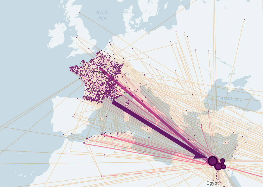
Figure 1: Trajectories of French expatriates in Egypt, 1792-1882
The map in figure 1 is a static, partial view of a larger interactive map, which uses the tool Flowmap to display 15,962 journeys inferred from 10,001 deeds in consular civil registers. The interactive map is available here. Viewers can zoom in and out to examine mobility at different scales; hover over trajectories to obtain information on the numbers of journeys between locations; and change settings, for instance to animate flows or cluster proximate locations. Further information on how the data was processed is accessible here.
Another mode of visualization, enabled by the geospatial analysis tool kepler.gl, allows for the layering and filtering of information. This alternative representation can be explored here:
Figure 2: Trajectories of French expatriates in Egypt with filters, 1792-1882
Figure 3: Origin to last known location per three-year period, 1792-1882