
PARISH GEOGRAPHIES
Here, the residents of each of Angoulême's central parishes are clustered together. These clusters are arranged so as to reflect the parishes' geographic proximity.
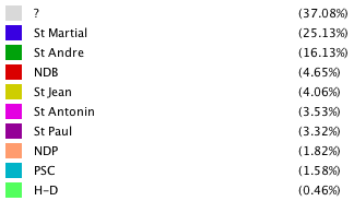
From this graph, it is easy to see how geography might have played a role in the formation of social networks. In aggregate, residents of a given parish are more likely to have relationships with members of an immediately neighboring parish than with residents of more distant ones. The small group of people from Petit Saint Cybard (in cyan), for instance, appear pulled away towards larger nearby hubs – those of Notre Dame de Beaulieu, St André, and St Jean. Also worth noting is how the hub representing St. Martial includes by far the most people from outside of Angoulême. This makes sense given that Angoulême sits on a hilltop promontory, with a principal point of access in St. Martial.