
Spring Creek, TX

On October 12, 2020, the TROPOMI instrument on the Sentinel-5 satellite detected an unusual event in or near Spring, Texas. It was a very large emission of methane -- a Turkmenistan-scale event -- and it was in an unexpected place.
There are 182 sites of ultra methane emissions in the 1800 Histories map that are associated with oil and gas in Texas. But only one, the Spring site, is in a major metropolitan area. It is in the greater Houston area, at the very north of Harris County, close to the meandering course of Spring Creek, which is the boundary with Montgomery County. This is an idyllic neighborhood, full of greenways and parks and a botanic garden. Immediately to the north, there is the township of The Woodlands, planned half a century ago -- by the philanthropist and pioneer of shale oil extraction, George Phydias Mitchell -- as a new sort of "hometown," an "all-encompassing community where the natural forested environment would be preserved, and residents could live, work, learn and play."
The locations indicated in the 1800 Histories map are imprecise. The lat/long coordinates -- {30.11,-95.44} in the case of the methane emission site near Spring, TX -- denote a 15km-radius circle and not a point in space. But in the history of energy, it is an interesting circle. Its center, on the map, near Spring Creek, is to the north of "Energy Drive," and just to the west of Interstate Highway 45, the North Freeway.
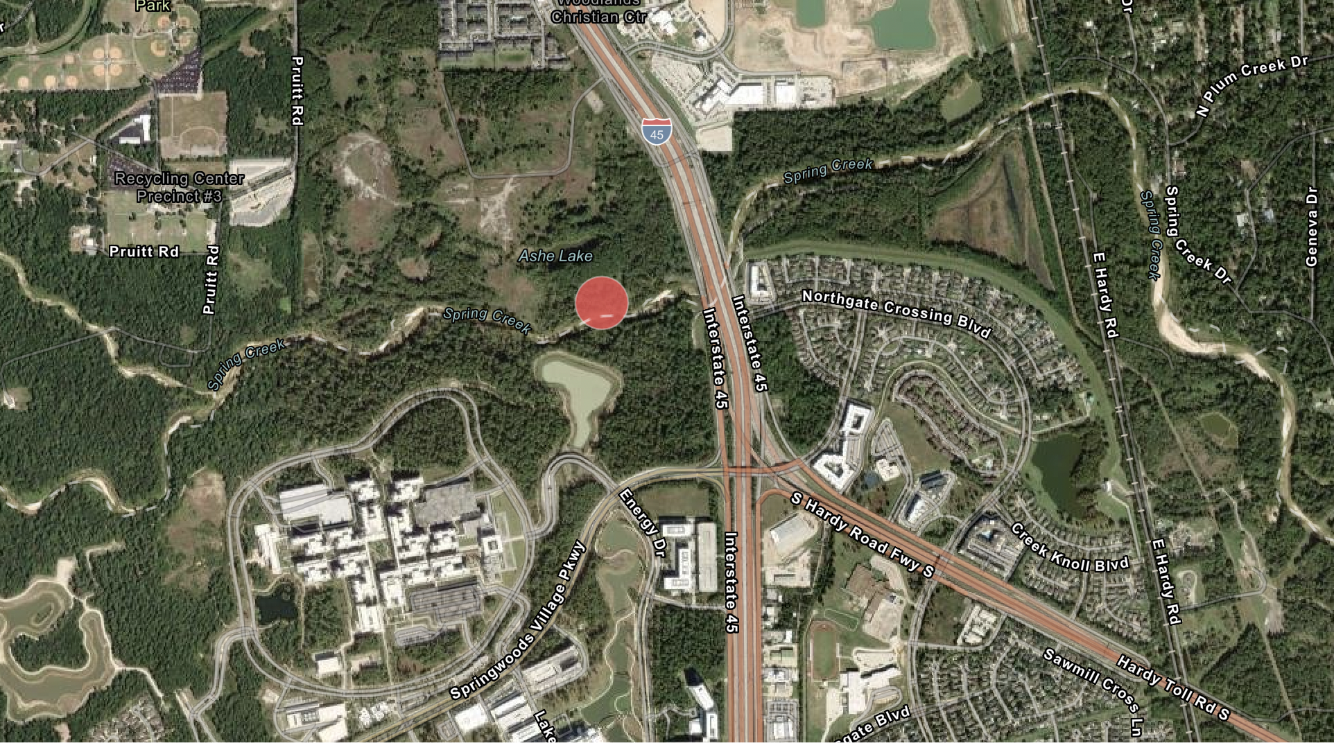
This is a familiar site, as it happens, in the contemporary iconography of energy history. For Spring, TX is the location of the luminous, energy-efficient, landscaped "Houston Campus" of ExxonMobil. In the company's description, "the facility opened in 2014 and accommodates more than 10,000 employees and visitors." It was "constructed to the highest standards of energy efficiency and environmental stewardship." It is located "on 385 wooded acres immediately to the west of Interstate Highway 45 (I-45), at the intersection of I-45 and the Hardy Toll Road." In the more laconic description of Google Maps, the campus is to be found at {30.10712/-95.44496}, or less than a kilometer from the center of the methane emission circle.

This is not the sort of place where one would expect to find ultra emissions of methane. Almost all the ultra emission sites in Texas are in the west of the state, in the dusty, empty, crushed lands of the Permian Basin and the Eagle Ford Shale. There are no sites in the suburbs of Dallas or Austin; there are sites with the same (very large) rate of emissions as the Spring Creek site in Turkmenistan and in Wuhai in western China. But something happened, in Spring, TX, on October 12, 2020, that was visible to the TROPOMI instrument. It was an event -- event number 1613 in the data that are the basis of the 1800 Histories project -- that consisted of an emission of methane at the rate of 53 tons per hour.
So this is the enigma. What was it that really happened on October 12, 2020? There was a nadir-viewing, imaging spectrometer on a satellite, 824 km overhead, that was looking down at Texas, and transmitting data to Darmstadt or Leiden, in the bleak autumn of the COVID-lockdown. There were climate scientists who analysed the data. There are historians, now, who are looking at the site where the methane was observed, which is itself changing over time. They (or we) are looking at history from below, or from the level of the ground, the buildings, the individuals working and living there, the soil, the material below the soil.
The juxtaposition of the view from above and the view from below is disorienting. Even the maps of the area around {30.11,-95.44}, which are the point of departure for the inquiry, are layered in time, one upon the other. The 1800 Histories map is itself a composite. (The chyron-like legend at the bottom of the 1800 Histories map acknowledges "Earthstar Geographics | CONANP, Esri, HERE, Garmin, FAO, NOAA, USGS, EPA," for the area and its surroundings.)
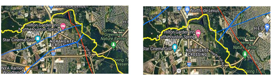
The multiple maps of the 15-km radius circle -- which extends in the north to the "George Mitchell Nature Preserve" in The Woodlands, and in the south to the "Mercer Botanic Gardens" -- show different activities and different moments in time. In the 1800 Histories map, the ExxonMobil campus site is annotated with the names of the buildings, "Energy Parking," "Energy Center," "Science Parking," "LAB," "Computing Facility," "Shack," "W4". In other maps, "W" is spelled out; it denotes "Wellness." One road map, available online in March 2024, adds a "WellSmiles Dental Clinic" in the middle of the campus, and another shows a Chick-fil-A. On a third map, there are Bitcoin ATMs along the roads to the east and south of the campus.
Towards the north of the 15-km circle there is another large corporate site, the headquarters of the Huntsman Corporation in The Woodlands, and its chemicals technology center. There is an OXY Tower in The Woodlands (named after Occidental Petroleum) and the former Anadarko towers (Anadarko Petroleum, sold to Occidental in 2019).
There is Research Forest Drive and Technology Forest. There are creeks and lakes and forests. This is an area, still, of woodlands, "ash, American beech, bald cypress, elm, sweetgum and black gum, various oaks and maples, pecan, sycamore, linden (basswood), and the tuliptree."
Then there are the maps of the invisible landscape. The National Pipelines Mapping System (NPMS) of the US Department of Transportation shows the gas pipelines that traverse the area: two in particular, that cross I-45 near the town line between Spring and The Woodlands. The Public Viewer of the Railroad Commission of Texas shows oil and gas wells that lie below the surface of Harris and Montgomery counties.


The view of the landscape, in the maps layered upon maps, is itself disconcerting. Or rather, it is only the constructed environment of mobility -- the triangle of highways, I-45, the Hardy Toll Road, and the Grand Parkway -- that is recognisable in all the maps. It is a way to orient oneself in space, even as the highways have in turn changed and extended over time.
The public record of what happened on October 12, 2020, or the evidence of events in time, which is the historian's recourse, is disconcerting in different ways. The Houston Chronicle, the Courier of Montgomery County and the Spring Observer were preoccupied at the time, like newspapers everywhere in the world, with the COVID lockdown and the US presidential election. Parts of Harris County were suffering from the effects of Hurricane Delta. There was news of environmental loss, as so often. The following day, October 13, there was a "black plume of smoke," associated with high levels of "1,3-butadiene, a carcinogen," after a TPC Group petrochemical facility "lost power" and was "flaring unspecified hydrocarbons." But this was in South Houston, more than 50 km from The Woodlands. Earlier in the summer, the Montgomery Courier had reported on the high incidence of premature births among mothers living close to the Eagle Ford Shale, to the west of Houston.
There was no news, or none that I have found so far, about the methane event that took place on October 12 at {30.11,-95.44}. There is no record of the episode in the Air Emission Event Report Database of the Texas Commission on Environmental Quality (TCEQ), and nothing in the US EPA's Inventory of greenhouse gas emissions. I was directed by the Open Records division of the Railroad Commission of Texas to the TCEQ, and a Public Information request to the TCEQ elicited the reply that "we were unable to locate any responsive information in the possession of the TCEQ."
So this is the view from below, the historian's view, and it is as always imperfect. There was an event, seen from above, and was it even an event, for the individuals who were there when it happened? The maps tell multiple stories, and so does the evidence, such as it is. This is what the process of inquiry is like, in climate science and in the social sciences.
The micro-histories in the 1800 Histories of Methane project are an experiment in putting together the different kinds of inquiry -- the view from below and the view from above -- and they ask two, related questions. The first is about what really happened, in the sense of trying to find out why there was a particular, large emission of methane at a particular time and in a particular place. The second is also about what really happened, in the sense of how it really was, in the place where the event happened, and in the sense of the history, sometimes over a long period of time, of how the place came to be the sort of place where there were likely to be methane emissions.
The promise of the first question, or the first inquiry, is that it becomes possible to identify a causal story, to provide new information and to make it more likely that the emissions will not happen again, because the pipeline that was leaking will be repaired, or the old gas well will be re-plugged. The promise of the second question is that it becomes possible to understand some of the history of climate change, as the outcome of different individual and collective choices, which vary over space and time, and which are all more or less reversible, because they are the choices of living beings and living societies.
These are questions about probabilities. But the eeriness of the view from above and the view from below -- the view from 824 km, via Darmstadt in the COVID lockdown, and the view from the tulip trees, or the view of the individuals who were working on the pipelines that traversed the North Freeway -- is itself part of the process of collaborative inquiry.
I have a historian's opinion about the first and more practical of the two questions. It is the view, that is to say, of a historian who is far from Houston at the moment (although not as far away as I am to provincial France in the eighteenth century.) The least unlikely source of the methane emissions that constituted event 1613, on the basis of the evidence from below, is the most obvious. The source of the event on Spring Creek is similar to the sources of so many oil and gas-related methane emissions everywhere in the world. There was a routine maintenance event in one of the two gas transmission pipelines that traversed I-45 just to the south of the ExxonMobil campus, travelling from the southwest to the northeast, and converging, about 5 km away, near the Rayford Crossing RV Resort.

These are the pipelines that are depicted in the NPMS map, although the NPMS provides no information about leaks or maintenance events (and warns the viewer to look only at a distance; "Pipelines, LNG Plants and Breakout Tanks are only visible at zoom level 14 or lower.") The places where pipelines connect, and the associated valves, are points of particular vulnerability for leaks; I am grateful to my colleague Steven Wofsy for discussion of this.
There is no publicly available information about a large pipeline leak in or near Spring, TX on October 12, 2020 -- a flare of 53 tons per hour -- in the incidents report of the US government's Pipeline Safety Administration, or in the Texas Railroad Commission's list of pipeline incidents. Pipeline maintenance events -- when the flow of gas is interrupted, sometimes at two proximate locations -- in order to conduct repairs are not recorded publicly. But the oil and gas ultra-emission sites in the 1800 Histories map are clustered, elsewhere, around pipeline routes; in Uzbekistan or over a 3,000 km expanse of central Russia. Even in the micro-environment of the Houston suburbs, pipelines are a plausible source of methane emissions.
There are other, less likely sources of the ultra emission of methane detected from space in October 2020. There are old oil and gas wells beneath Spring, TX (and beneath The Woodlands), visible on the Texas Railroad Commission maps, and these are also possible source of emissions. They are unlikely to be the source of the ultra emission of 53 tons of methane per hour in 2020. But they are a poignant illustration, all the same, of the extent to which the layers or levels of history -- the history of Houston, or of the oil industry -- are conserved in the contemporary landscape.
The Texas Railroad Commission's public map thus shows nine different oil or gas wells lying within the perimeter of the ExxonMobil Houston Campus itself; there is a "plugged oil/gas" well below the structure now identified as "ExxonMobil - Nature Parking Garage," and a "plugged oil" well below "ExxonMobil - Houston Campus - The Lab."


The wells are identified as part of the "Kuhlman Oil Field," which was listed in a ![United States Department of the Interior, Geological Survey [USGS], "Spring Quadrangle, Texas," 1960](../spring_images/IMG_0239-preview.jpg "United States Department of the Interior, Geological Survey [USGS], \"Spring Quadrangle, Texas,\" 1960") US Geological Survey map for 1960; the operators -- the Cockburn Oil Corporation, Pan American Petroleum (which was incorporated in 1916, and became part of Amoco in 1954), Casey & Weempe -- are part of the early history of the oil industry in East Texas. They are a part, in turn, of the history of climate change.
US Geological Survey map for 1960; the operators -- the Cockburn Oil Corporation, Pan American Petroleum (which was incorporated in 1916, and became part of Amoco in 1954), Casey & Weempe -- are part of the early history of the oil industry in East Texas. They are a part, in turn, of the history of climate change.
There is a further unlikely explanation for event 1613. It is that the event was not associated with the oil and gas industry, as identified in the data by Lauvaux et al. that is the basis of the 1800 Histories map. The TROPOMI instrument sees methane, or CH4; it does not see the sites that are the sources of the methane. So it is possible that the emission in or near {30.11,-95.44} was in fact a different sort of event; one of the events that are described in the data as coming from a "human" source.
There is a recycling center just north of Spring Creek, and a large landfill site 15 km to the south on the Hardy Toll Road, near the airport (like the Matuail landfill site in Dacca, Bangladesh); there is another large landfill site to the north-east in Montgomery County. There was a different enigmatic ultra emission site in East Texas, at {31.25, -94.69}, which is apparently in the middle of the Angelina National Forest; it too is near the Angelina County landfill site, a gas pipeline and an EPA Superfund site.


Another less likely explanation is that there was a different kind of accident. Even closer to the site of event 1613, less than 7km to the southeast, there is a major Union Pacific Railroad Yard. "Old Town Spring" is a tourist and shopping destination, as "the historic location of a 19th century railroad hub;" in November 2022, two years after the methane ultra-emission event in or near Spring, TX, the railroad tracks near the yard were the site of a deadly accident when a "fuel gas ignited." Railroad hubs, too, are the sites of leaks and flares.
These are no more than possibilities. A future micro-history of Spring, TX will, I am sure, be able to answer the question of what happened on October 12, 2020. The future historians, or investigators, will be able to ask their own questions; to talk to the Texas Commission on Environmental Quality, or the maintenance workers who were repairing pipeline intersections, or the reporters who covered real estate or environmental pollution for the Houston Chronicle, or ExxonMobil's "environmental and property solutions group," or the company's "director of technology," who was interviewed by the Financial Times at the Spring campus in November 2023, to announce that the company would be joining the UN's Oil and Gas Methane Partnership. They, or we, can return to the evidence from above; we can ask the climate scientists to look in more detail at the 2020 TROPOMI data (which is expensive), or use AI to determine methane emission profiles, as our colleague Thomas Lauvaux and others are doing. There are questions of historical fact that can be answered, and the answers can reduce accidents (or leaks) in the future.
So then there is the second question, about what really happened and the history of climate change. This inquiry into the contemporary history of Spring, TX and The Woodlands has been a journey, along the way, into the much longer, apparently inexorable but eventually contingent causes of global climate change, in choices that have been made in particular places and times.
One set of choices has been Houston itself. The city, as Jonathan Levy wrote here, "represents both the cause and consequence of a way of life that is now fated to warm the planet." Houston is one of the places in the world where the vectors of causation -- from the atmosphere to the ground or the land, and from the land to the atmosphere -- coincide in space, if not in time. There were 45 days in the summer of 2023 when the temperature in the city exceeded 100 f (37.8 c); there were twelve catastrophic floods over the first two decades of the 21st century, of which the most visible was the outcome of Hurricane Harvey. Spring Creek itself lies within a floodway.
![https://www.harriscountyfemt.org/]](../spring_images/SpringCreek.jpg "https://www.harriscountyfemt.org/]")
The production and distribution of oil and gas in the Houston region have caused emissions to the atmosphere over many generations; the distinctive pattern of energy-intensive consumption has been the outcome of more than a century of changes in land use, culminating in the auto-industrial age of the late 20th century.
 The 1960 US Geological Survey map -- the map that shows the Kuhlman Oil Field where the ExxonMobil campus now stands -- depicts an unfamiliar world. There were no more than a few scattered houses in what is now Spring, TX and in the wooded settlements to the north. The population of Spring had been 700 people in 1947, and the entire population of Montgomery County, to the north and east, was still, in 1960, less than 27,000. By 2022, the county's population had increased to 678,490.
These were logging and agricultural lands. Montgomery Country -- to the north of Spring Creek, and the ExxonMobil campus -- was settled in the middle decades of the 19th century as a rural community of the southern United States. There was a plantation economy based on cotton production; in 1860, the population of the county was 5,479, of whom 2,416 were enslaved people. The main town, Conroe, is now famous in the historiography of the United States as "A Texas Town," in Annette Gordon-Reed's On Juneteenth.
The trees of Montgomery County were the foundation of the next phase of economic expansion. There was a logging boom, and the construction of multiple railroad lines that transported raw and treated timber. The two Superfund sites of the US EPA in the county are in Conroe. One is at the former Conroe Creosoting Company that treated timber for more than half a century, starting in the late 1940s, with the toxic and potentially carcinogenic preservatives pentachlorophenol (PCP), creosote, and copper chromated arsenate (CCA); the other is at the former United Creosoting Company. A recent modest experiment in collective transport -- commuter bus departures from The Woodlands to the "Energy Corridor" in downtown Houston -- sets out from a location with the evocative name of the Sawdust Park & Ride.
It was the advent of the auto-industrial age, starting in 1952 with the construction of the first Interstate Highway System expressway in Texas, IH 45, and its extension to Conroe in 1959, that made possible the modern local economy. The roads north of Houston were in the early history of Texas notoriously difficult, little more than "cow paths." With the expansion of highways and automobile traffic, there was a new oil-intensive pattern of suburban and urban development, or an ignition-industrial age. Conroe is now one of the fastest growing large cities in the United States, and the expansion of the area around Spring and The Woodlands was built around the new road networks.

This journey into the micro-history of methane in and around Spring, TX has itself been a (virtual) road trip along the highways of Harris County and Montgomery County. I-45, the Hardy Toll Road, and the Grand Parkway have been the point of orientation in the changing landscape. The landfill site near the airport was on Hardy Road. The "Woodlands Towers" (that were once the OXY and Anadarko towers) are on Woodloch Forest Drive. There is a landfill site specializing in construction waste at "2525 Loop 336 East Conroe."
The inquiry has been a journey, in turn, into the vectors of causation by which the consumption of energy in ordinary life leads to climate change. Transportation is the largest source of US emissions of greenhouse gases, and its share is increasing over time. Life in the Houston region is energy-intensive because it is so hot and humid, and because it is inaccessible, now, without driving around. This is the outcome of the half century of auto-centered development -- and of the institutional power of the auto-industrial complex -- that is so visible in the history of Montgomery County. The Woodlands was created as a community where individuals could walk or bike to work; in 2015, "approximately 70% of households [had] access to two or more vehicles and 80% of employed adult residents drive to work alone."

The Woodlands was inaugurated, in 1974, at a time of pessimism and possibility. It is a melancholy anniversary, for me, because I was a cautious observer, then, of the prospect of a different future. The "present power" of the "auto-industrial complex," I wrote in a book called Paradise Lost, published in 1973, or "of auto corporations, components companies, auto dealers, motel owners, highway construction companies, of the highway lobby and of suburban real estate developers," was "no more than a temporarily dominant but mortal mutation of economic evolution."
There had been the great Transpo Expo of 1972, with its promise of a "space age of mass transportation;" there was the Nixon administration's Office of Emergency Preparedness report on energy conservation, also in 1972, that described the "preferential policies" by which government "favors development of auto and highway transport," and concluded that "this growth in automobile consumption" of energy "seem[s] unacceptable given present concern over the environment" and over energy security. Even the first "Woodlands Conference," in 1975 -- supported by George Phydias Mitchell, the founder and philanthropist -- was a celebration of energy conservation, as well as of "sustainable futures."
Half a century later, the temporary dominance of the auto-industrial age has endured. Automobiles and "light trucks," particularly SUVs, account for 52 percent of all US energy consumed in transportation in the US. The US EIA expects that the share associated with light trucks alone, which is now 32 percent, will expand further over the coming decade. Air transport, by comparison, accounts for only 10 percent of total energy use in transportation, and all rail transport, freight and passenger, for less than 2 percent. This is the auto-industrial society of 2024, and it is the outcome of preferential policies refined over half a century; from the "SUV loophole" in the regulation of fuel efficiency, to the auto industry bail-out of 2008-2009, to the public investment of the 2020s in the infrastructure of roads and electric vehicles. There are EV charging stations in Conroe, TX, and a proliferation of federal tax credits, state incentives and rebates for the electrification highway- and auto-industrial economy of Texas.
Then there are the vectors of causation -- from the land to the atmosphere, or to climate change -- associated with the production and distribution of oil and gas. This too is a story of change over time, deep in the history of Montgomery County, and deep in its soil. The 1960 US Geological Survey map of Spring, TX is a delicate filagree of pipelines and creeks. There is Spring Creek and Willow Creek and Cypress Creek. There are three west-to-east pipelines that traverse the road (then a two-lane highway) that is now IH45. The map even provides some support for the hypothesis that the episode of the ultra-emission of October 2020 can be explained by a pipeline leak. The place where the pipelines connect, or intersect, was a pipeline crossing even then, sixty years earlier. It was a three-way crossing, at the time, very close to the junction of a different, north-to-south pipeline.

The Geological Survey map is a vista, in turn, of the long history of the oil industry, described in the celebration volume for the ExxonMobil campus as the "first 14 decades of achievement," or "eight generations of talented individuals." To the south-east, there is an indication of the road to Humble, Texas, which was the largest oil field in Texas in 1905, and the home of the Humble Oil Company that became part of Exxon. There is the Kuhlman Field. To the north-west, there is the Bender Oil Field, near what is now the George Mitchell Nature Reserve. Further to the north, there are directions to Conroe, which was itself the site of an oil boom, starting in 1931. It was the site of the terrible Conroe explosion and oil fire of 1933 that has become part of the visual history of Texas. At the edge of the Conroe Oilfield, now, there is a State of Texas Superfund site at Wigginsville Road "a mercury-contaminated groundwater plume of unknown origin."


There are hundreds of old oil and gas wells beneath the landscape of Montgomery County; near Magnolia Drive in Conroe, or The Woodlands Sports Park, or clustered around the George Mitchell Nature Preserve. Many are described as "plugged," in the Texas Railroad Commission map. Some are identified with existing businesses, Texaco or ExxonMobil or the Koch Pipeline Company. Others are annotated with the names of long-forgotten oil companies, or of the estates and heirs of long-lost owners.
This is part of the long history of energy in Texas. But it is also part of the history of the preferential policies that have sustained an energy-industrial complex that has been at least as resilient as the auto-industrial complex of the mid-20th century. There are the "fossil fuels consumption subsidies" that are calculated by the International Energy Agency as worth $1 trillion, worldwide, in 2022; there are the waivers and tax incentives and authorizations and exemptions that have shaped the landscape of modern Texas.
It is a history that endures today. There was nothing much that anyone noticed, or reported in the local news, on October 12, 2020, the date of the ultra-emission of methane gas that took place in or around Spring, TX, and was detected by the TROPOMI instrument. But something did happen -- another coincidence -- in the routine regulatory politics of the Texas oil industry, as on so many other dates over the past half century.

On the same date, October 12, 2020, the US EPA, in Washington, DC, received a submission from the governor of Texas to request "National Pollutant Discharge Elimination System (NPDES) authority for discharges from produced water, hydrostatic test water and gas plant effluent, hereafter referred to as oil and gas discharges." (This was an effort, supported by the oil and gas industry, to transfer responsibility for regulating emissions from the EPA to the Texas Commission on Environmental Quality.) The submission was deemed complete on November 12, 2020, shortly after the US presidential election, and the dénouement came in the last days of the Trump administration. There were 6 comments in favor of the change, and "approximately 130" opposed. The EPA held a (virtual) public hearing on January 5, 2021; the request was authorized on January 15, 2021.
The history of The Woodlands is again a melancholy story. George Mitchell's own company "participated in approximately 10,000 wells," according to his philanthropic website. The company then diversified into "natural gas processing, transmission, drilling services, and real estate," and owned "50,000 acres of timberland north of Houston." By the time the "master planned community" of The Woodlands was inaugurated in 1974, Mitchell had become inspired by the 1972 book The Limits to Growth, with its evocation of "the twin problems of population growth and resource depletion."
To read the proceedings of the first "Woodlands Conference" of 1975, now, is to find oneself in a Rita Hayworth hall of mirrors. There is a sense of impending "catastrophe" and of a "crisis of civilization." Human societies are "collapsing," and there are "obstacles to voluntary energy conservation." There is anxiety about the "market system" and about "dependence on foreign oil." There is the possibility that the "low-temperature heat" associated with any "energy conversion technology" will lead to "major global effects," "some time during the next century." There is the idyll, eventually, of a "sustainable steady state."
This is a language of crisis that is still recognizable. But the cause of the anticipated catastrophe was radically different in 1975. It was supposed to be the impending scarcity of fossil fuels, and the "trauma of a sudden and complete collapse of the stored energy resource base." This was the "problematique" of The Limits to Growth, by which George Mitchell had been so inspired. One conference participant (from the Rocky Mountain Institute) mentioned "other deleterious influences (such as increased levels of CO2)," that could lead to "global climatic problems" "fairly early in the next century." But the focus was on the "limits" to "energy resources;" the US Geological Survey had "recently announced a drastic reduction in its estimates of total recoverable United States oil and gas reserves."
I was a cautious observer, once again, of the "revisionist pessimism" of 1975; a Cassandra, or a raven croaking about the improbability of doom. I was on the side of the optimists, more or less, about the possibilities of new technologies, and even of prices. I thought the "'crisis'" was "concocted." But I also tried to be an observer of the "alternative energy policies" of the Nixon and Ford administrations; in 1973, I took a (non-virtual) trip to the shale rocks of western Colorado, that were then so much in fashion; it was "the pulverizing of Colorado's shale mountains" to which the "prophets of alternative energy look[ed] forward with rapt optimism."
. © James St. John.
https://www.flickr.com/photos/jsjgeology/29618104914/in/photostream/")
The energy policies of the 1970s, as so often in the long history of the oil and gas industry, were an involuted story of the political economy of regulation; of influence, exemptions and tax incentives, including the differential rates of depletion allowances in relation to oil, gas and shale, that were discussed by the US Senate in 1975. This was well before the large-scale use of the relatively low-cost "fracture" or fracking technologies of our own times. But it was possible, even then, to see a dismal future (the raven croaking not of doom but of loss): in 1973, "at the worst, such an alternative energy policy could appropriate the projects of future governments. It would bequeath to them responsibilities for energy conservation even more arduous than the responsibility for used coal lands and for salt mines full of radioactive waste. Energy planning, like transportation policy, requires the most troublesome political choices. But like the city planning and highway construction and aviation policies of the 1940s and 1950s, present energy decisions could leave a dismal heritage for the twenty- and fifty-year future."
George Mitchell of The Woodlands was himself, as it turned out, at the center of the future energy economy. Amidst his philanthropy, focused on "land conservation" and "sustainability education," in the narrative of his website, he "maintained a keen focus on growing his energy and real estate business." In the early 1980s, he and his team "began testing new technologies in the shale formations of the company's North Texas gas fields." The "biggest discovery" came in the 1990s, and it was a technique of extracting natural gas from shale rock by fracturing the rock. As recounted in a tribute on the website, "what started as a tiny frack in 1981 evolved over the years to a water-based frack in 1997 that finally yielded results that were commercially viable."
Mitchell eventually became "the father of the shale revolution." In 1979, according to an article in the Journal of Petroleum Technology, Mitchell's company "pumped the largest massive hydraulic fracture stimulation on record at the time," at a gas field north of Houston with the evocative name of North Personville. Personville or "Lost Prairie," is some 190 kilometers north of The Woodlands, near the main highway from Houston to Dallas. In 1981, the company extended its operations further north, to the west of Dallas and Fort Worth, in the Barnett Shale that became "the model for shale resource plays worldwide."

The Mitchell company's discovery had been not a gas field but an additive; a way of making water, salt and guar gum into a viscous liquid, a "salt water frack," that reduced the cost of fracturing (or pulverizing) shale formations, and releasing gas from "hard, 'tight' rocks." This too had been the outcome of government subsidies for "alternative energy" from fossil fuels, going back at least to the Nixon administration's policies of 1973. There was an enduring political economy of preferential policies, from the Natural Gas Policy Act of 1978, which introduced a "tight natural gas price incentive," to the tax credit for fuel from "nonconventional" sources of 1980, to half a century of publicly supported research and development.
In 2002, Mitchell sold his company to Devon Energy of Oklahoma, for $3.5 billion, and continued with his "philanthropic interests at an entirely new level." In 2012, he and former New York City mayor Michael Bloomberg wrote an article in the Washington Post about the future of fracking. Their proposal, as "voices in the sensible center," was for "better state regulation of fracking," including "disclosing all chemicals used in the hydraulic fracturing process," "protecting groundwater," "improving air pollution controls, including capturing leaking methane," and "reducing the impact on roads, ecosystems and communities."
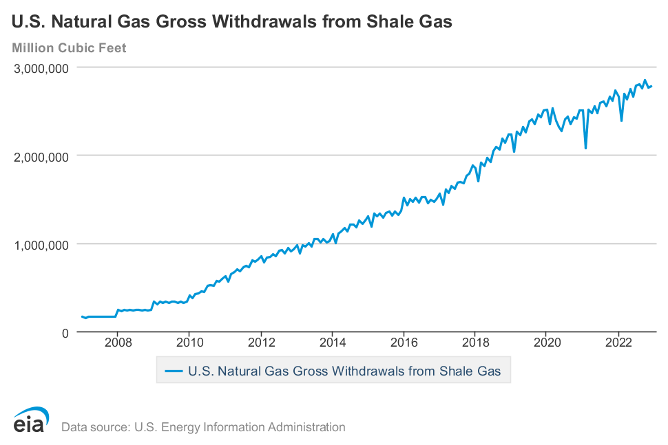
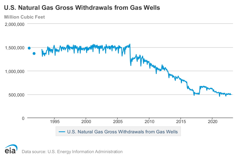
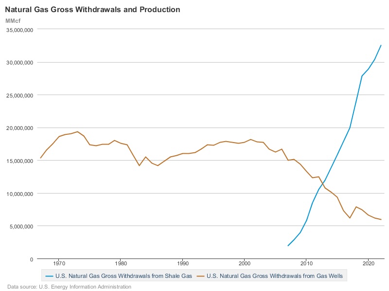
In 1974, when George Mitchell inaugurated The Woodlands, "gross withdrawals from gas wells" in the United States amounted to 22.8 mmcf (22.8 x 10¹² cubic feet.) In 2007, the quantity had increased only minimally to 24.7 mmcf; by 2023 it had increased to 45.6 mmcf. Most of the "marketed production" of natural gas -- production for sale, that is to say, since natural gas is "primarily made up of methane," and methane is being produced or lost all the time -- now comes from the fracking of shale. Withdrawals from "shale gas wells" were first measured in 2007, and they accounted for 8 percent of total withdrawals; by 2022 the share of shale was 74 percent of all natural gas produced in the US.
The ultra methane emission of October 2020 on Spring Creek is an enigma because The Woodlands, and even Spring, TX, are not the sorts of places where the causes of climate change are usually to be seen (or smelled or inhaled.) There are diffuse causes associated with energy-intensive consumption that are visible even in the green suburbs; air conditioners and the congestion constituted, as in The Woodlands, by the "80% of employed adult residents [who] drive to work alone." But the causes of climate change that are associated with the production, distribution and industrial use of energy -- the contamination of air, water, soil and landscape that is co-located with concentrated emissions of methane and other greenhouse gases -- are somewhere else or out of sight. They are in the poor and deprived parts of the great metropolitan regions, as of rural America.
This is the geography of environmental injustice, and it is part of the infrastructure of Houston's history. The landfill sites in greater Houston are in the areas, still, of relative poverty and deprivation. Within Spring, TX, the large landfill site on Hardy Road is in the old industrial part of the community, near the airport. In Montgomery County, the landfill site that takes construction waste is in Conroe, in another long-established industrial area.

The highest levels of pollution from particulate matter in Houston are in the poorest parts of the city, with the highest proportion of Black residents. In the environmental historian Robert Bullard's words, "the polluting facilities are all located in our neighborhoods," and these are the communities that also have "elevated asthma, respiratory problems, diabetes, heart disease, stroke or COVID;" "'Oh my God, it's the same map!'" There is a gradient in contamination and in the composition of the population. The population of the City of Houston, to the south, is 67.2 percent Black and Hispanic; in Spring, TX, with its old industrial region and its prospering suburban north, it is 61.7 percent Black and Hispanic; in Texas overall it is 53.6 percent; in The Woodlands, the Black and Hispanic population is 22.2 percent of the total.

There was news of pollution in Houston, in the weeks surrounding the episode of the methane emission at Spring Creek on October 12, 2020 (the episode that was itself unnoticed.) But it was news from elsewhere, or at the edge of the horizon. The "black plume of smoke" on October 13, 2020 at the TPC facility, associated with high levels of "1,3-butadiene," was in a neighbourhood of South Houston that was already polluted; an English teacher at the Cesar E. Chavez High School, who saw the plume as she was driving to work, told the Houston Chronicle that she was "concerned that this incident might be swept under the rug because it occurred in a lower socioeconomic part of town."
The study of the high incidence of premature births, reported earlier in the summer of 2020 in the Montgomery Courier, was an investigation of mothers living close to flaring in the Eagle Ford Shale. Eagle Ford is a region of intensive oil and gas production, extending across 27 counties in Texas, from north of Conroe to the border with Mexico. Its development was itself the outcome of George Mitchell's "tiny frack," as described on the Mitchell website: "now that same technique is used in oil and gas plays across Texas in the Eagle Ford Shale, the Permian Basin and across the country."

But the areas of maximum flaring were far from The Woodlands. Two of the counties most affected, Atascosa and Dimmit, are places with relatively low per capita income, a very high proportion of Hispanic residents, and multiple sources of pollution. A coal-fired power plant in Atascosa County was identified in 2019 as the coal site with "the worst contamination in the country;" plans for further expansion of lignite mining there were approved in 2023.
Even the "clean" or low-CO2 electricity produced in natural gas-fired power plants arrives after long and often circuitous journeys. The journeys begin, now, in the places that are out of sight, amidst all the "chemicals used in the hydraulic fracturing process," all the costs to groundwater and all the air pollution about which George Mitchell and Michael Bloomberg warned in 2012. These, too, are the vectors -- the horizontal vectors -- of the causes of climate change.

The story of the event at Spring Creek in October 2020 is surprising because The Woodlands is not the sort of place where methane emissions happen, at least on the "ultra" scale of 53 tons of methane per hour. But the (long) micro-history of the episode is also a different - and an opposite -- sort of story. For the inquiry into the area around {30.11,-95.44} has shown how difficult it is, even in the leafiest of suburbs, to be at a distance from the infrastructure of the causes of climate change.
There were the gas pipelines and the landfill sites and the explosion at the railroad yard. Some of the possible (implausible) causes of the event were specific to Texas: the old oil and gas wells below the landscaped surface of the energy research campus. But most were part of ordinary life, in the energy-industrial society that has been constructed at such cost over the half century since the foundation of The Woodlands.
In the longer historical perspective of this inquiry, there are multiple reasons for foreboding. It is as likely now as it was in 1973 that "present energy decisions could leave a dismal heritage for the twenty- and fifty-year future." The "green" infrastructure that has been the object of so much public and private investment is itself an infrastructure of mobility, of roads and bridges and airports and charging stations, and of new sources of energy, renewable and "transitional."
The horizontal vectors of climate change extend far beyond the journey from the Eagle Ford shale to the Houston suburbs. An expert witness at the 1975 US Senate Finance Committee hearing on shale depletion allowances summarised the energy policies of the recent past as a strategy of "Drain America First." The strategy of the 2010s and 2020s can be described as one of "Fracture America First." US exports of natural gas have increased about fourfold since 2015. The gas that is produced in Eagle Ford -- in part from "onshore assets" owned by CNOOC (China National Offshore Oil Corporation) -- or in other American shale "plays" has its own long journeys; by pipeline to liquefaction facilities to tankers to pipelines to power plants, using energy (or losing methane) along the way.
The virtual or financial vectors are even more baroque. The ExxonMobil results (or profits) for 2023, announced in Spring, TX, were enhanced by "advantaged Guyana and Permian assets;" the company's principal countries of operation, after the United States and Canada, were Guyana, Angola and Argentina. The company has an extensive new operation to produce liquefied natural gas in Papua New Guinea. It may soon, with its $59.5 billion merger with a shale oil and gas company, Pioneer Natural Resources, become "the dominant player in the Permian Basin." Some of the (horizontal) causes of climate change are proximate to Spring, TX and some -- the equivalent of the "present energy decisions" of 1973 -- begin there, extending to the fracked land of the Permian Basin and to the South China Sea.
There are reasons to be optimistic about new technologies, as there were in 1975. Of the companies in The Woodlands, Occidental, which bought Anadarko -- named after the Anadarko Basin that is one of the enduring sites of methane emissions from the production of shale gas -- is a member of the UN's Methane Partnership; the Huntsman company is turning methane into nanotubes; ExxonMobil is investing in lithium production, and thereby in the economy of batteries for electric vehicles.
The sense of foreboding is the outcome, rather, of what is not being done. Electric vehicles are clean because they do not emit CO2 and other greenhouse gases (in their use, as distinct from their production and eventual destruction, or in the production of the energy they use.) Natural gas is clean because it emits less CO2 than the other fossil fuels that are used in the production of electricity (although it is composed, mostly, of methane, which is itself a greenhouse gas, and which is flared, lost and leaked over the course of its long and unobserved journeys.)
To target methane emissions from oil and gas is a clean or "low-hanging" objective, for international organizations, because it is a matter of "strategic mitigation actions" and "science-based policy options." But there are other places, now as fifty years ago, that are out of sight, in Atascosa County or in the Lualaba province of the Democratic Republic of the Congo. There are other kinds of pollution, some co-emitted or co-located with methane emissions, and others the unintended or unheeded effects of the long transition to an eventual post-carbon economic growth. This is pollution that is hard to aggregate in strategic targets. There is the energy sprawl of land to be used in the production of unconventional energy, in the horizontal wells of shale development or the renewable energy of solar parks. There are volatile organic compounds and PFAS and particulate matter and the contamination of groundwater; there is the loss of wildlife.
The pending merger of ExxonMobil and Pioneer was described in the New York Times, when it was announced in 2023, as "a bet that U.S. energy policy will not move against fossil fuels in a major way." The even more melancholy prospect, in the perspective of half a century, is that the worldwide electric economy, with its own baroque vectors of the causes of environmental destruction -- from the lithium and cobalt mines to the new highways and the rusting debris of old electric vehicles -- will loom, eventually, as the monument to choices that were never made.
The micro-history of Spring Creek is itself, amidst all this foreboding, a distant source of hope. The point of the 1800 Histories project is to look at the really existing places where the ultra emissions of methane happened; at the other sources of pollution and environmental destruction in these same places; and at the connections between these local histories and the vectors -- in space and time -- of the causes of climate change. The micro-, in the project, is a way of understanding the macro- of global climate, and of imagining a different future.
The old Kuhlman Oil field, in Spring, TX, is now invisible; a landscape, below the soil, of lost, deserted oil wells. It is covered over by a landscaped "campus," that has been covered, in turn, or "reforested," with "native plants." This will at some point be the destiny, however distant, of the entire oil and gas industry, in Texas and elsewhere. It will be like Rome, in Freud's simile of the traces of memory in the mind, with its lost, deserted temples, Santa Maria sopra Minerva, that lie "buried" in the soil of the modern city; "a mental entity with just as long and varied a past history: that is, in which nothing once constructed had perished, and all the earlier stages of development had survived alongside the latest."
. Wikimedia Commons.")